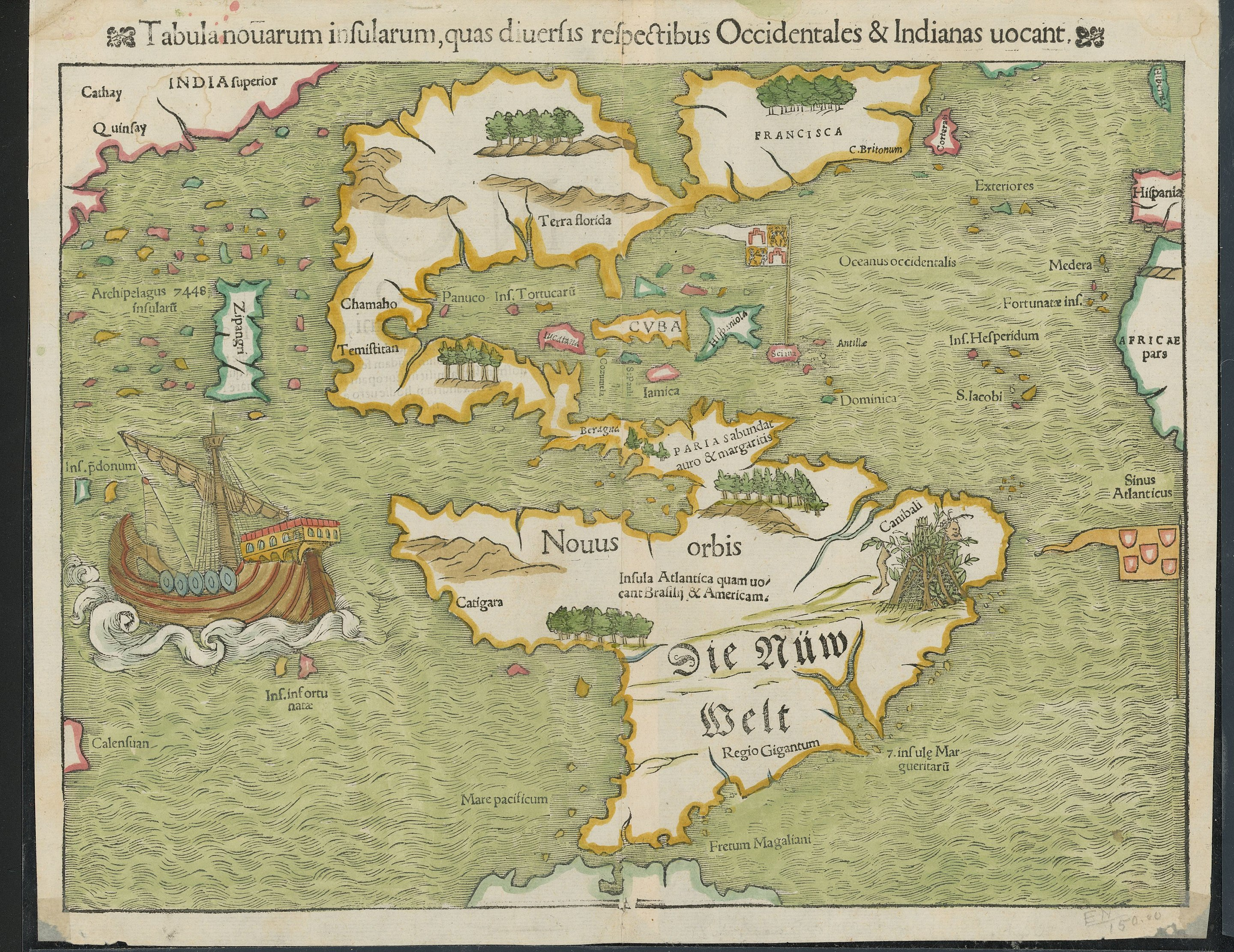
There have been multiple accounts created with the sole purpose of posting advertisement posts or replies containing unsolicited advertising.

Accounts which solely post advertisements, or persistently post them may be terminated.

AA5B ,

Anyone know what Zipangri is? Could that be Baja California, or what?

Edit: Japan. Is apparently just off the coast of Mexico

TonyTonyChopper ,
@TonyTonyChopper@mander.xyz avatar

Apparently Japan’s shape wasn’t well known either

lauha ,

That explains the pearl harbour

BackOnMyBS ,
@BackOnMyBS@lemmy.autism.place avatar

This makes sense given the popular knowledge at the time. The reason Columbus set sail wasn’t because he was a genius that knew the Earth was round when everyone else didn’t. We knew the Earth was round since antiquity. I can’t remember who, but some ancient Greek had calculated the circumference of the Earth using the angle of a shadow, distance to an equinox, and simple trigonometry. They guy was less than 5% off with his rudimentary calculation, which is impressive considering that he paid some dude to measure the distance between two towns by walking it. Anyways, the Western Europeans thought that Japan was farther east, somewhere around where the words “Terra florida” are on this map if I recall correctly from memory. When the Niña, Pinta, and Santa Marimba (party boat! jk, it was Santa Maria named after the “virgin”) landed on the most beautiful land that human eyes had ever seen, they knew they hadn’t landed on Zipangri/Cipangu/Japan. Instead, they thought they had landed on some island off of India, which is why they called the locals “Indios” (Indians). Anyways part 2, they thought that Japan was much further east than it was. I imagine that since they hadn’t found it for this map yet, they though it must be right out of sight of the western coast of North Vespucci (America).

What I’m curious about is that 7448 inflating archipelago. Anyone have an idea on what that’s about?

criticon ,

Santa Marimba

I’m stealing this! 😂

originalucifer ,
@originalucifer@moist.catsweat.com avatar

cuba has always been cuba?!

FlyingSquid OP ,
@FlyingSquid@lemmy.world avatar

I’m guessing the Taino called it something else.

originalucifer ,
@originalucifer@moist.catsweat.com avatar

ha, good point. i was just kinda shocked to see a legible 'cuba' and 'florida'

Karyoplasma ,

Terra florida means something like “land with many flowers” in Spanish.

Zoboomafoo ,
FlyingSquid OP ,
@FlyingSquid@lemmy.world avatar

FWIW, this gives a somewhat different origin, although says it is derived from the local name.

www.etymonline.com/word/Cuba

Viking_Hippie ,

either “great place” or “where fertile land is abundant”

So…first impressions pretty positive?

PhlubbaDubba ,

IIRC their word was something like “Kolba”

PhlubbaDubba ,

How in sam hill are their vowel Vs and consonant Us in this‽

Greg ,
@Greg@lemmy.ca avatar

Ships were huge in the 1500s!

WoodScientist ,

Now I really want to see an animation of what the European discovery of the planet looked like. Imagine a time lapse of a Civilization game, as the map is slowly revealed. I want to see that, except actual history.

lauha ,

Also make the map shape and style match that times maps.

frezik ,

Sibera was part of India back then.

leaky_shower_thought ,

i like how our boi did highlighter colors.

superior india is just right of china. probably quinfay there is “shanghai”.

there’s also that canibali place with bush tents hung with a leg and a happy face.

HubertManne ,

wow. spain is north of florida.

waigl ,

The only label on the map that’s both on Latin and in old German.

  • All
  • Subscribed
  • Moderated
  • Favorites
  • [email protected]
  • random
  • lifeLocal
  • goranko
  • All magazines